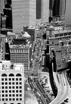
Imagine a situation in which your morning commute consists of bumper to bumper traffic for miles in a sea of vehicles. You are one of the unlucky 150,000 drivers traveling on a roadway originally designed to carry only half that many. Your knuckles turn white as you clutch the steering wheel trying to avoid a collision in a place where the accident rate is over four times the national average. Walking seems more appealing since you can traverse the city by foot in about half the time it takes to drive. This is no nightmare. It is Boston's Central Artery, part of an elevated transportation system that cuts right through the center of downtown Boston.
How has commuting through Boston come to this?
"Much of it stems from the old theory for designing transportation systems," according to Professor David Noyce, Professor of Transportation Engineering at UW-Madison.
The original idea was to simply elevate roadway systems to carry traffic in and out of the city while leaving much of the subterranean infrastructure intact. In addition, governmental process involving transportation projects, such as Boston's initial construction of its Central Artery, used to be much more of a dictatorship. Today, mass public outcry would likely limit the clearing of so many houses and businesses, says Noyce.
Fixing Boston's transportation problems eventually became part of a much larger project now known as the "Big Dig." At the heart of the Big Dig was the task of transforming the Central Artery from a roadway in the sky into a tunnel directly below. Not only would the tunnel remove an eyesore, but it would also remove a barrier, reuniting the north end of Boston with the rest of the city. However, not even the Secretary of Transportation of the state of Massachusetts and the leading advocate for the Big Dig could have predicted the project would have lasted nearly 20 years and cost roughly 14 billion, making it the largest and most complex construction project ever in America.
As the Big Dig progressed, funds drained, plans changed and people began to wonder if they would ever be able to see the light at the end of the tunnel. In light of the budget constraints, planners shrank the tunnel dimensions to 17 feet, not much higher than many bridge clearances.
Since the dimensions changed, coming up with a new system of traffic signs became more difficult. Consequently, researching the issue was handed over to Noyce and his colleague Don Fisher at the University of Massachusetts-Amherst. With a limited number of tunnel exits, missing one would mean a detour for drivers who would then have to travel a considerable distance out of their way.
Assisting Noyce and his colleague in their research was one of the few driving simulators of its kind. Located in the UMass Human Performance Laboratory, the integrated system includes the driving cab of a Saturn sedan, three display screens spanning a total of 180 degrees in the horizontal direction and a sound simulator, all of which work together to create a realistic driving simulation. In addition, the simulator records driver response and even coordinates the movement of other vehicles based on driver response. "We were able to recreate the driving experience right down to the shading and sizes of the tiles on the tunnel walls," says Noyce.
As a result of simulator research, the signing was done in order to effectively communicate necessary information to the driver in the tunnel which incorporates low profile signs, redundancy and information spanning multiple lanes. Low profile signs were used as a result of the tunnel height constraints while redundancy and multiple lane use ensured that drivers had ample opportunity to see the signs. The opening of the northbound lanes of the new Central Artery in late 2002 has since provided drivers and planners with the light at the end of the tunnel.
A UW-Madison senior majoring in Civil Engineering.

wiscengr@cae.wisc.edu
608.262.3494
M1066 Engineering Centers Building
1550 Engineering Drive, Madison, WI 53706